Planning a road trip or vacation to the USA and not sure what to check out?
Here’s a list of 56 of the most beautiful places in the (western) USA, spanning from Texas to California and all the way up to Washington Montana.
Many of these must-see places are not very well-known and you’ll be astonished by some of the dramatic canyons, beaches, and rivers you’ll come across. The biggest problem will be finding time to visit them all!
Tip: Use WalletFlo for all your credit card needs. It’s free and will help you optimize your rewards and savings!
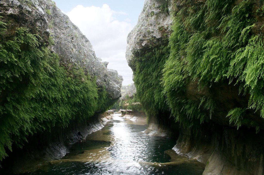
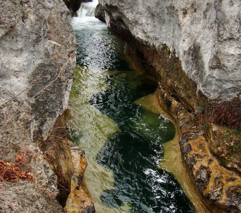
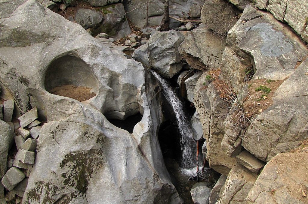
1. The Narrows (Texas)
Along a 1,000-foot stretch of the Blanco River in the Texas Hill Country, huge cylindrical walls of light limestone — shrouded with bright green ferns growing at their base — hang forty feet above emerald pools of water that are interconnected through an underwater network of caverns.
This stunning canyon exposes a ancient coral reef and many fossils, such as tiny coral polyps and calyces can be spotted embedded in the canyon walls. While it’s surrounded by private property, there are legal options open to the public to visit.
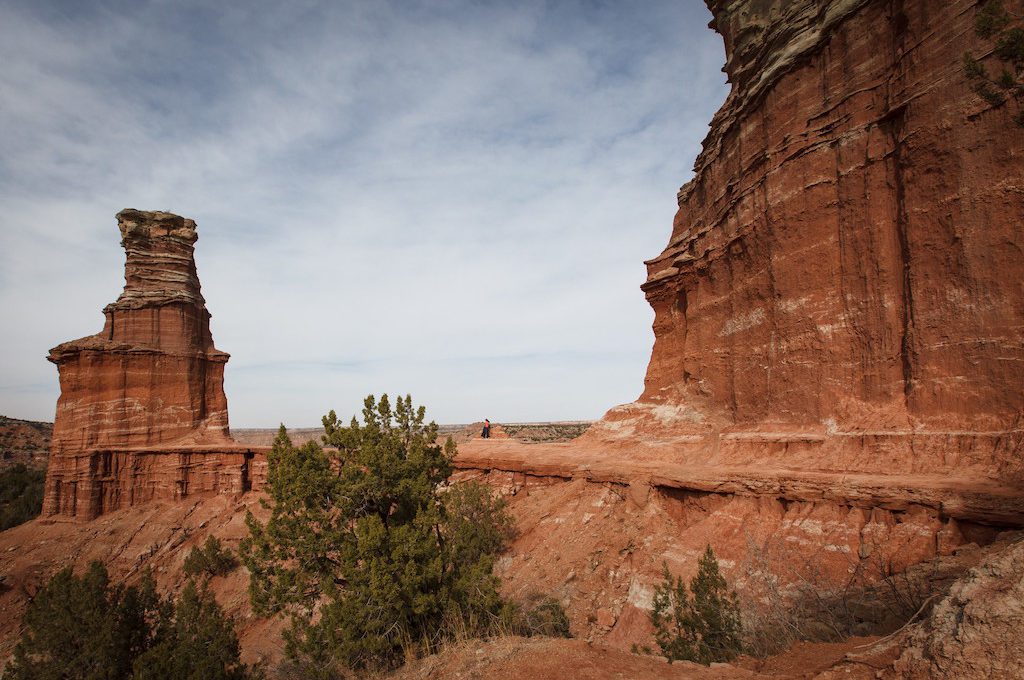
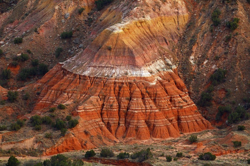
2. Palo Duro Canyon State Park (Texas)
Located in the Texas Panhandle near the city of Amarillo, this vast and picturesque canyon is believed to be the second largest canyon in the entire United States behind the one and only, Grand Canyon.
It boasts some of the most dramatic red-rock scenery in Texas and was also home to the Battle of Palo Duro Canyon, which marked the end of the Red River War and the exodus of the Great Plains Indians in the region.
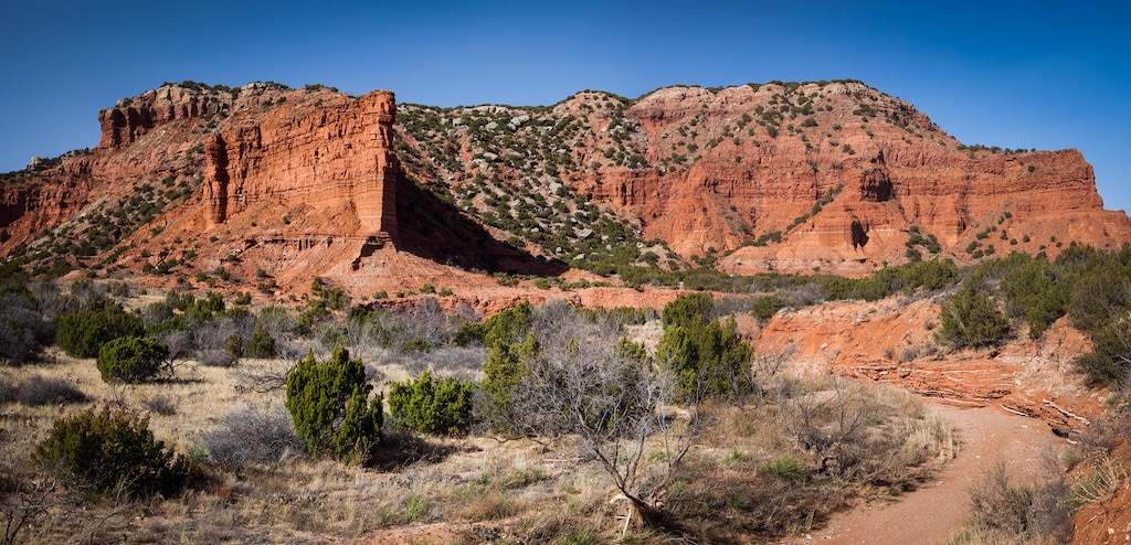
3. Caprock Canyons State Park (Texas)
Home to more stunning red sandstone, this park is more known for its bison herd. 80 descendants of the Great Southern Bison Herd roam here and all because of the efforts of cattleman Charles Goodnight and his wife Mary Ann who decided to save the last remnants of the Plains bison herd in 1876.
Today, these bison roam in a semi-free ranging site, offering an encounter with these wild beasts usually only found at National Parks in Wyoming or the Dakotas.
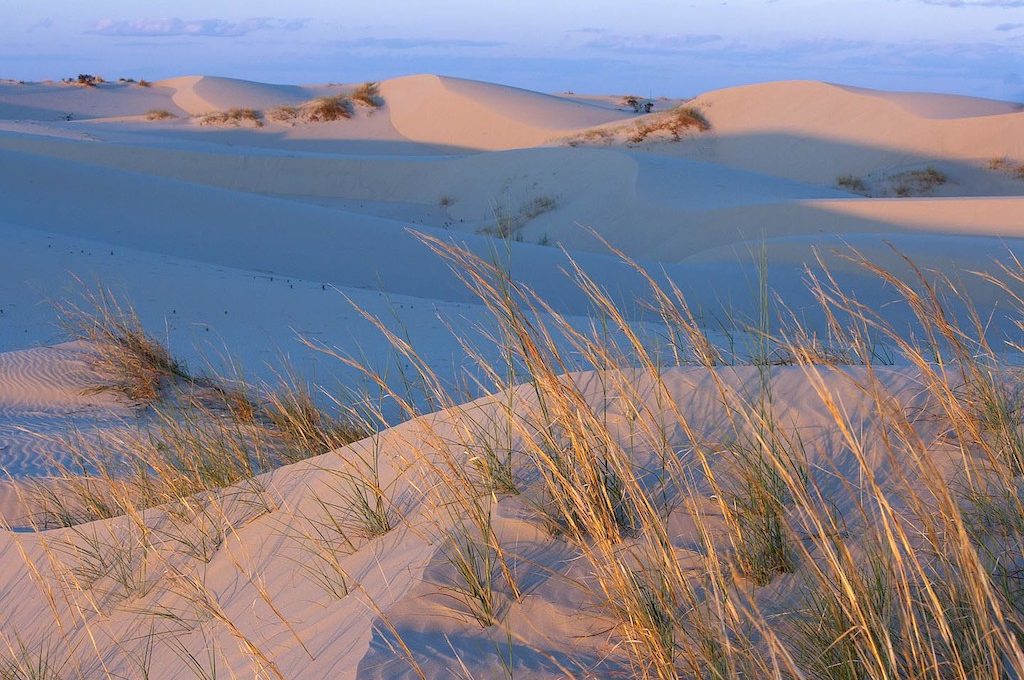
4. Monahans Sandhills State Park (Texas)
Monahans Sandhills is located along the former Comanche War Trail, which was a network of trails where skirmishes often broke out between the Apache and Comanche Indians as they fought to secure easily navigable terrain and precious natural resources.
Along with spectacular dunes, some up to 70 feet high, you can come across some of the Harvard Oak trees, which are trees that grow only to a couple of feet tall and produce giant acorns which were prized by Native Americans who once called this place home.
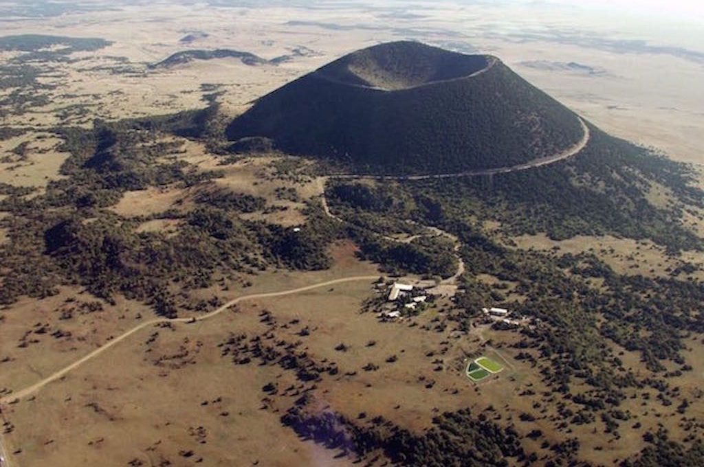
5. Capulin Volcano National Monument (New Mexico)
The imposing green mountainsides of Capulin Volcano stand as a reminder of the violent volcanic processes that shaped New Mexico tens of thousands of years ago.
One of the natural wonders of New Mexico, it’s noted as being one of the most easily accessible volcanoes in North America.
From its summit, you can sometimes see as far as Kansas before the horizon finally falls beneath the earth’s curvature. Just watch out for the swarms of hungered lady bugs who make their arrive back to the volcano each summer!
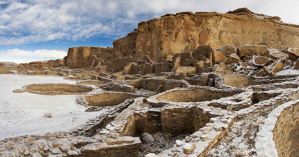
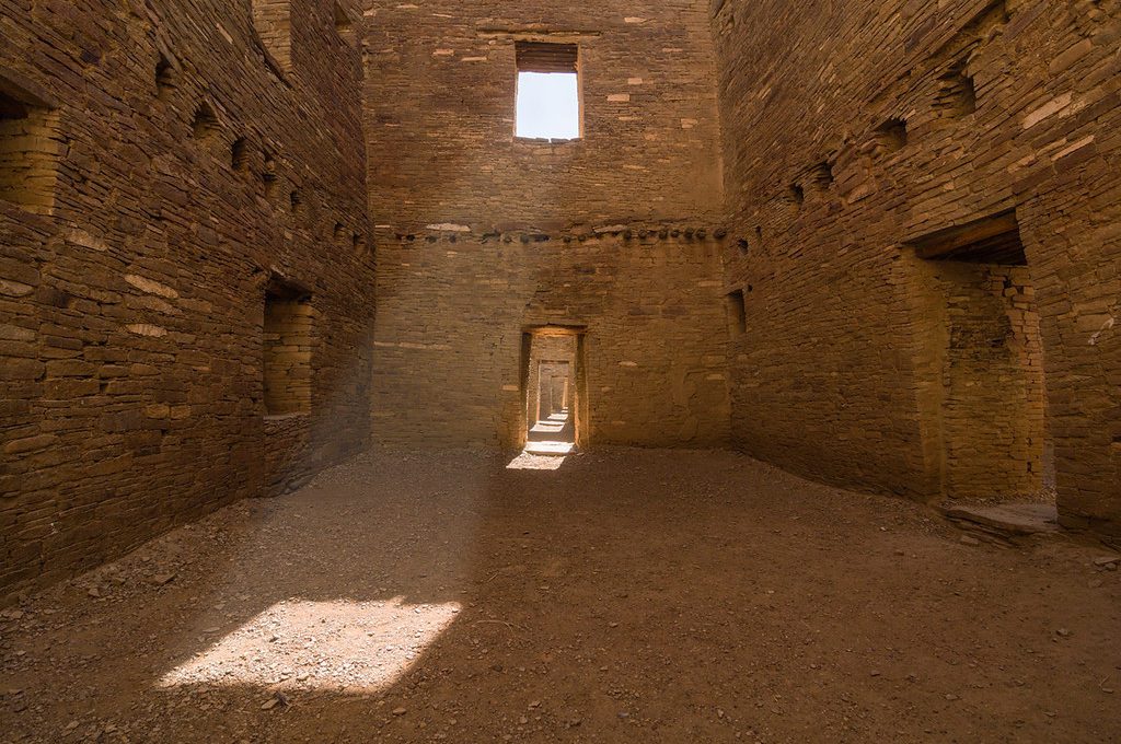
6. Chaco Culture National Historic Park (New Mexico)
The Chacoan built large structures here which were called “great houses” and the complexes and were so big that many believe that they were the largest buildings in North America until the 1800’s — one even rivaled the size of the Coliseum in Rome.
Unlike other cultures of the time, the Chacoan planned these buildings from the start before any construction took place.
Such planning was necessary as some of these massive structures sometimes took decades and even centuries to complete. Today, this World Heritage Site, which was once the primary hub for Native American civilizations of this region, still beckons for exploration.
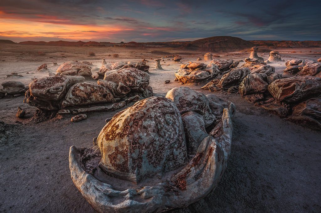
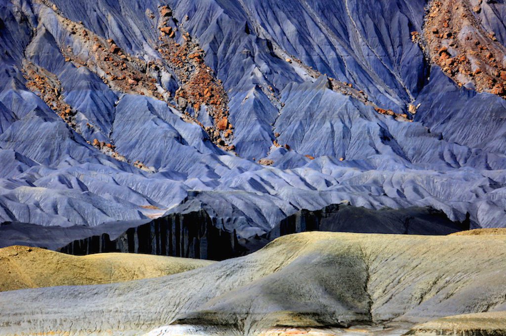
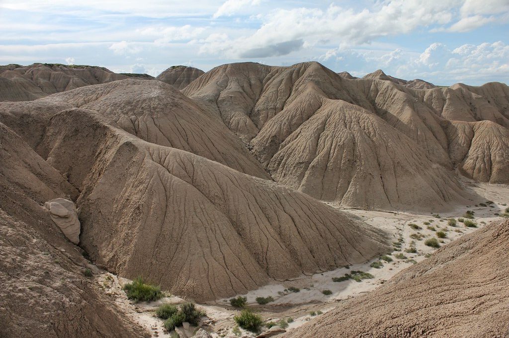
7. Bisti Badlands Wilderness Area (New Mexico)
The Bisti Badlands, also known as “De-Na-Zin Wilderness,” is a vast 45,000-acre wilderness area in the high desert of the San Juan Basin in New Mexico.
Once an ancient river delta covered with lush vegetation some 70 million years ago, it’s now home to an array of fossils and otherworldly rock formations that were the backdrop of the 1977 film, Sorcerer.
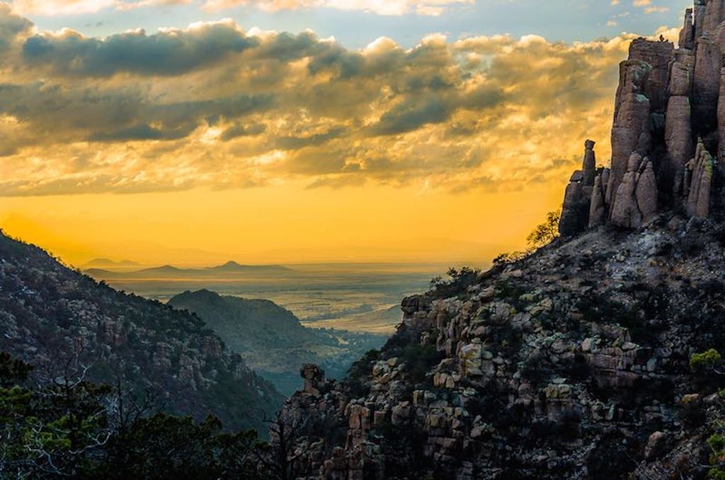
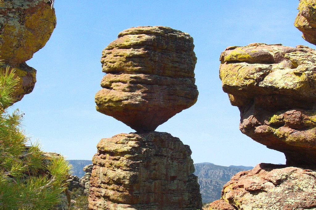
8. Chiricahua National Monument (Arizona)
Standing erect like stone Terracotta Warriors, rows of towering grey pinnacles dominate green hillsides, each uniquely chiseled and sculpted into its own work of art at this place known as “The Wonderland of Rocks.”
Once the home to a tribe of Apache Indians known as the Chiricahua Band, these rocks formed by volcanic eruptions over 27 millions years ago come in wide-range of gravity-defying positions that will surely blow your mind.
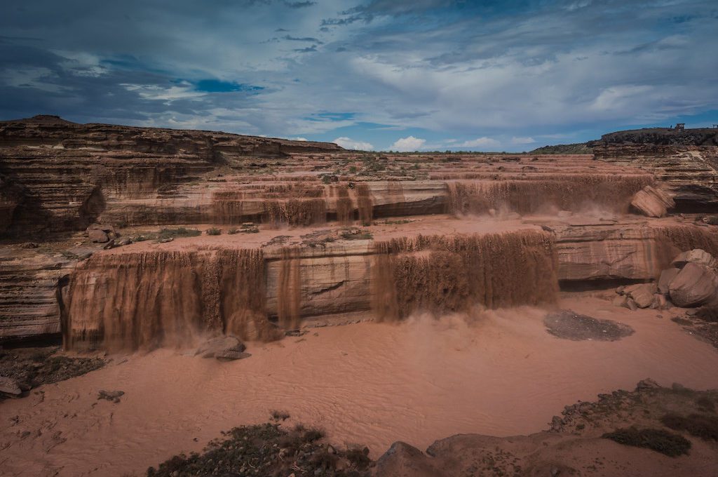
9. Chocolate Falls/Grand Falls (Arizona)
After monsoons and heavy spring run-off, the cliffs here transform a mucky hazard into a spectacular cascading waterfall known as “Chocolate Falls” that will leave any chocolate lover in awe.
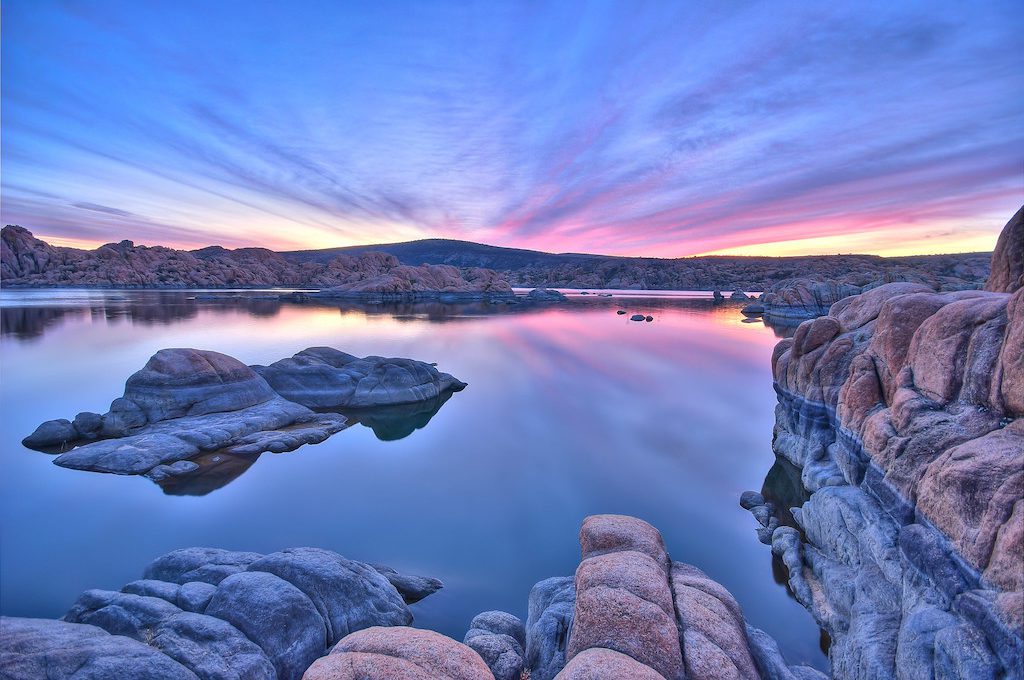
10. Granite Dells (Arizona)
Billion-year old granite boulders rise like grey submarines from the middle of a lake at The Granite Dells in Prescott, Arizona.
Here, an assortment of exposed bedrock – formed by a geological process known as “spheroidal weathering” – flank the still reservoirs where pink clouds stretch across both sky and water at sunset.
Throughout the endless piles of prehistoric rocks, several trails climb and meander beside beautiful lakes, as there are no shortage of exploration opportunities at The Granite Dells.
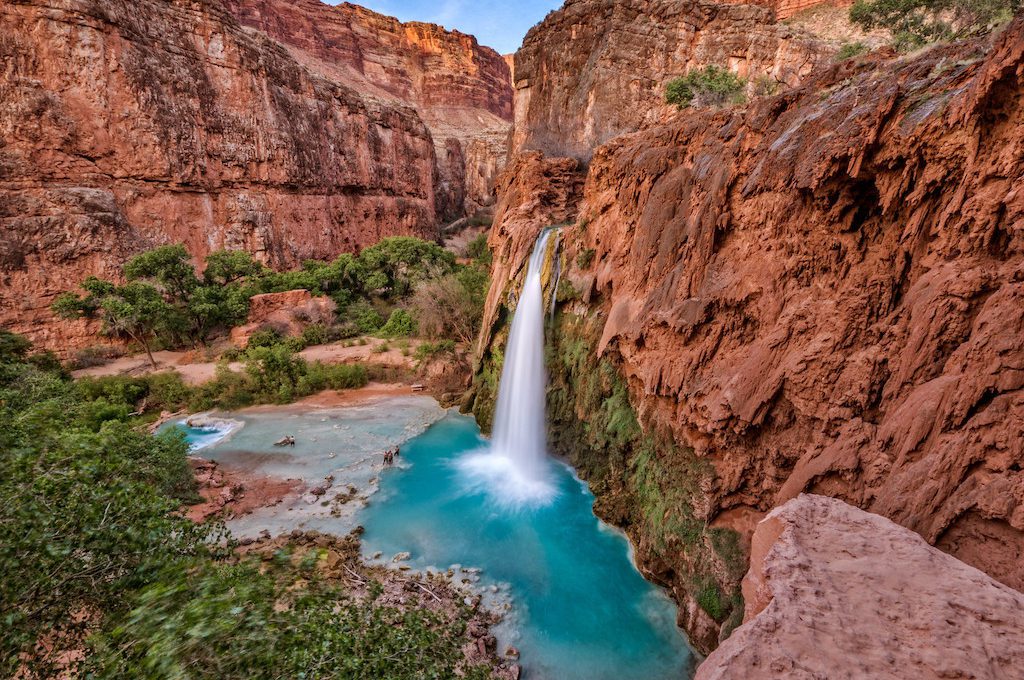
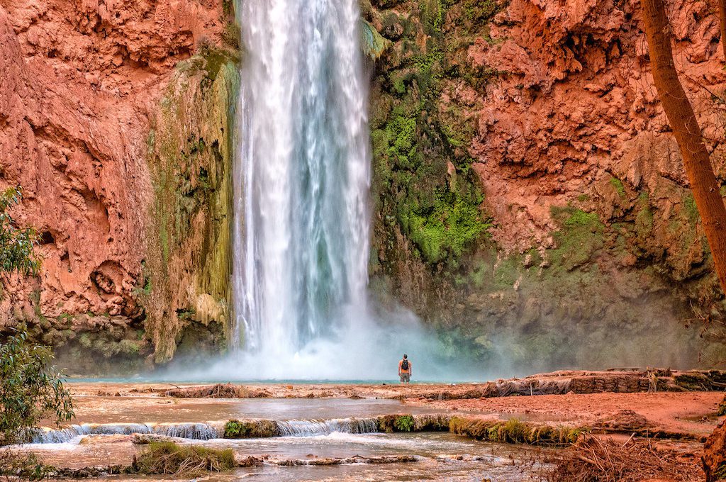
11. Waterfalls of Havasupai (Arizona)
Bright turquoise waters stream through red sandstone cliffs and pour over grand cascades at the Waterfalls of Havasupai, one of the best-kept secrets of the Grand Canyon.
Via a 10-mile hike, mule ride, or helicopter ride you can make your way to this gorgeous location and explore 5 different waterfalls, which pout into some of the brightest turquoise pools you’ve likely ever come across.
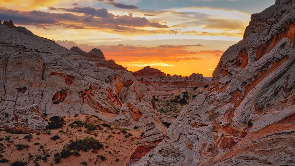
12. White Pocket at Vermillion Cliffs National Monument (Arizona)
Swirls of red, yellow, and white drape the sides of this otherworldly creation, and on top, mounds of white caprock form an overhanging crest resembling cake frosting.
It’s the unmistakable and bewildering scenery found at White Pocket. Geologists are still slightly baffled as to how these formations came to be and as you wander through the warped terrain it will be easy for you to see why.
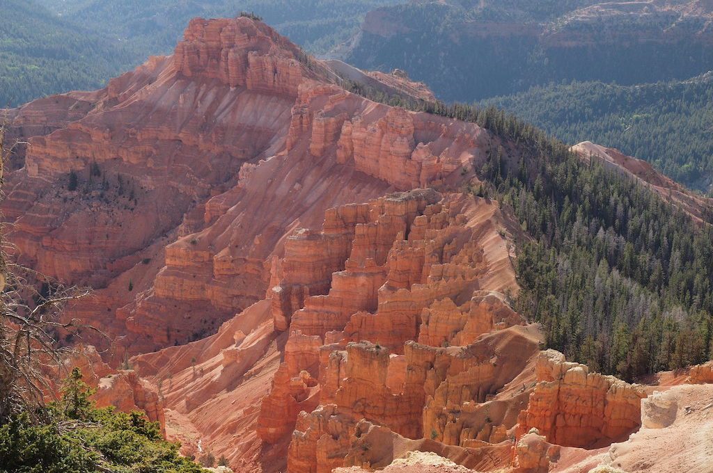
13. Cedar Breaks National Monument (Utah)
An assemblage of orange and white canyons, spires, and columns, contrasted with heavily forested ridgelines form a natural amphitheater that spans nearly 3 miles wide and rises to elevations above 10,000 feet.
Its cool mountain air is the perfect escape for visitors trying to get away from the summer heat and it’s also a great place to get up close with one of the oldest individually growing species of tree: the bristlecone pine, which can live for over 5,000 years.
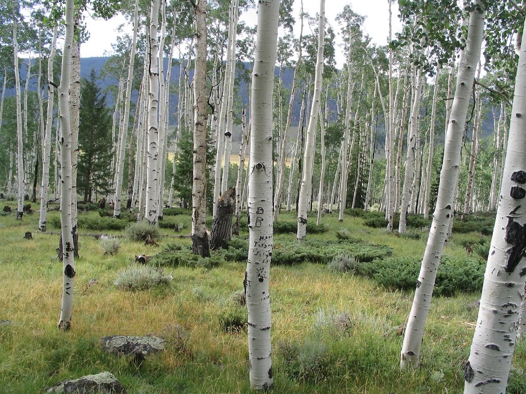
14. Pando at Fish Lake National Forest (Utah)
Found at Fish Lake National Forest, this massive collection of 45,000-plus trees, while vast and beautiful, appears to be nothing more than a large grove of quaking aspens.
However, unbeknownst to the average observer, a complex network of underground root systems crawl through the soils, connecting these trees so that each “tree” is actually a “limb” of one exceptionally large organism.
In fact, this creature called “Pando,” is believed to be the largest organism on the face of planet Earth and likely at least 80,000 years old.
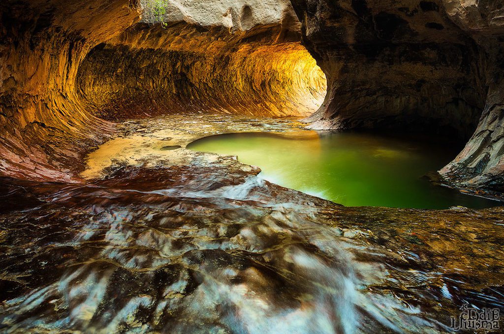
15. The Subway in Zion National Park (Utah)
At around noon, the sun sits above the tall canyons at Zion National Park and casts its rays at just the right angle, bouncing yellow light off the Subway’s cylindrical walls and illuminating an otherwise gloomy cave in a way that begs for exploration.
The Subway, tucked away in the heart of the Zion Wilderness, is a natural wonder like no other place on the planet where you trek through brilliant cascades, a bubbling creek, and even dinosaur tracks on your to discover this natural wonder.
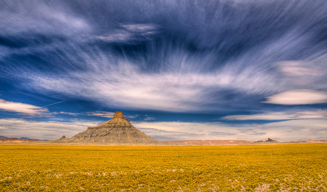
16. Factory Butte (Utah)
Although the lands stretching from Factory Butte’s pedestal are dominated by mud flats, badlands, and the kind of desolate topography that offers little hope for vegetation, a spectacular wildflower bloom occasionally carpets the desert floor in the spring and turns an otherwise barren desert landscape into a flourishing sight to behold.
And even if you don’t catch this amazing bloom that only occurs a couple of times a decade, the beautiful crumbling blueish-grey monoliths here are great photo opportunities themselves.
17. Fantasy Canyon (Utah)
Once covered by a large lake called Lake Uinta during the Eocene Epoch, this extremely delicate place, also known as “Nature’s China Shop,” is full of intricately designed sandstone formations that span a 10 acre rock jungle full of dripping pinnacles, wafery hoodoos, and twisted hollows.
At sunset, this exceedingly delicate assortment of geological art awakens in glowing fashion to produce one of the most stunning natural creations in all of Utah.
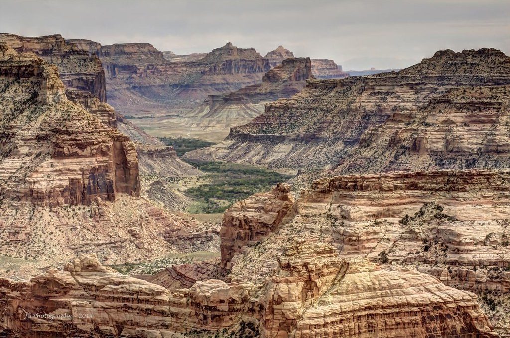
18. The Little Grand Canyon (Utah)
While not nearly as vast as the famous Grand Canyon in Arizona, the “LGC,” which is part of the San Rafael Swell, still impresses those who happen upon it and draws one in with its colorful cliffs and sweeping panoramic views.
This alien terrain bears such a resemblance to the planet Mars that the Mars Society actually set up a Mars Desert Research Station in the area. But whether your chasing Martians, stunning views, or ancient petroglyphs and pictographs this hidden gem won’t disappoint.
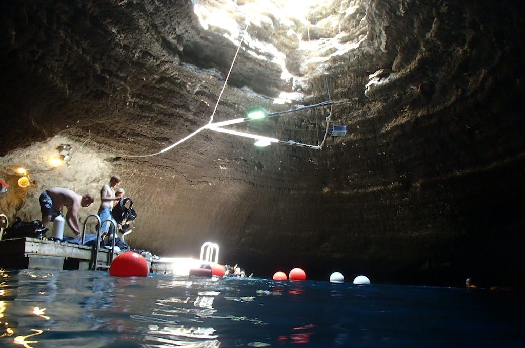
19. Homestead Caldera (Utah)
A large mineral-rock dome, the product of 10,000 years of mineral deposition, hangs 55 feet above the steamy blue waters of an active hot spring known as the Homestead Caldera. Staying a hot 90 to 96°F year round, these waters are the only place offering scuba diving opportunities in warm water inside the continental United States.
At the bottom of this hot spring, which reaches depths of 65 feet, numerous random objects have been pulled from a 25-foot thick layer of sludge including many coins and even firearms.
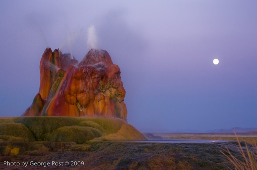
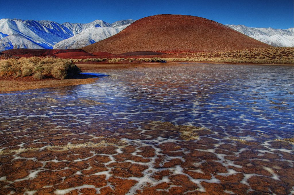
20. Fly Ranch Geyser (Nevada)
Hot water, rich in minerals, spews from several small vents atop a large mound draped with clumps and streaks of yellow, orange, and red at this hidden gem found in the vast and isolated Black Rock Desert in northern Nevada.
You’d swear its origins were extraterrestrial, but surprisingly this was created back in 1964 when geothermal energy tests went awry forcing a powerful water source, along with dissolved minerals, to rise through the permeable soils and begin collecting on the ground surface until it developed into the structure it is today.
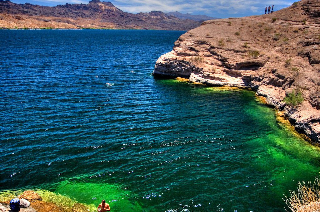
21. Placer Cove/Nelson’s Landing (Nevada)
Placer Cove, also known as Nelson’s Landing, is a hidden gem in southern Nevada where thrill-seekers hurl themselves off the cliffs of a small cove and into the clear green waters of Lake Mohave.
For those not looking to take a plunge into the water, a picnic along many of the open banks of the cliffs or simply walking the area and taking in all the great views of the area’s fresh, pristine waters is also a solid option.
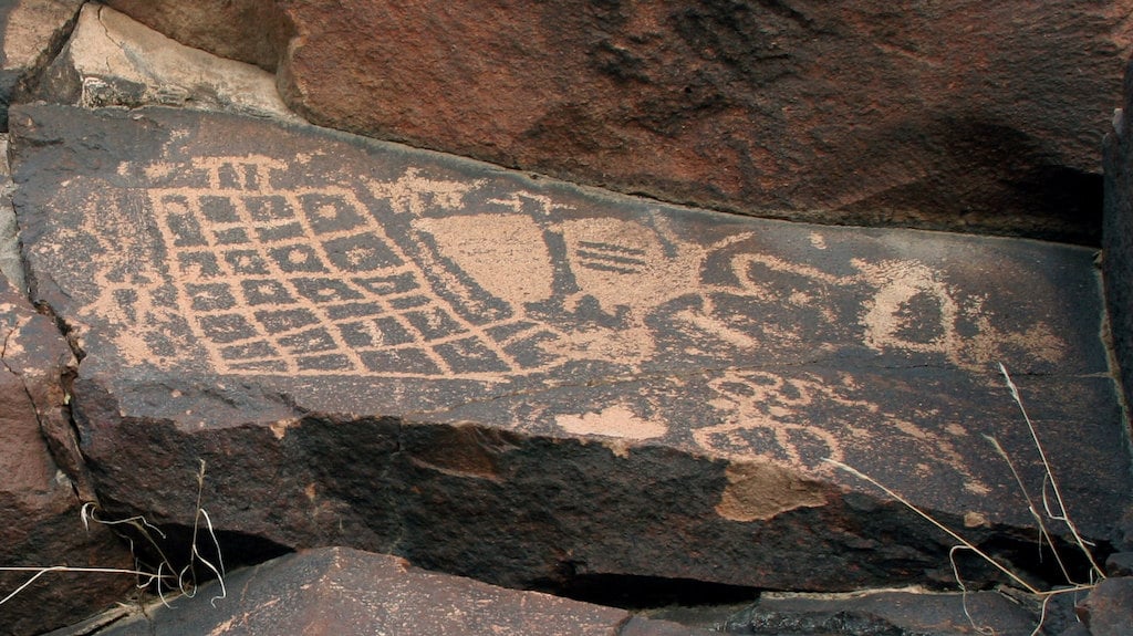
22. Sloan Canyon National Conservation Area (Nevada)
Created by volcanic action millions of years ago, Sloan Canyon is home to so many petroglyphs that it’s been called the “Sistine Chapel” of Native American rock art. Archeologists believe that Paleo-Indians inhabited Sloan Canyon as far back as 7,000 years ago and think that Puebloans from the Archaic Era are responsible for most of the petroglyphs found here which total over 1,700 and are carved into over 300 charred panels of rock.
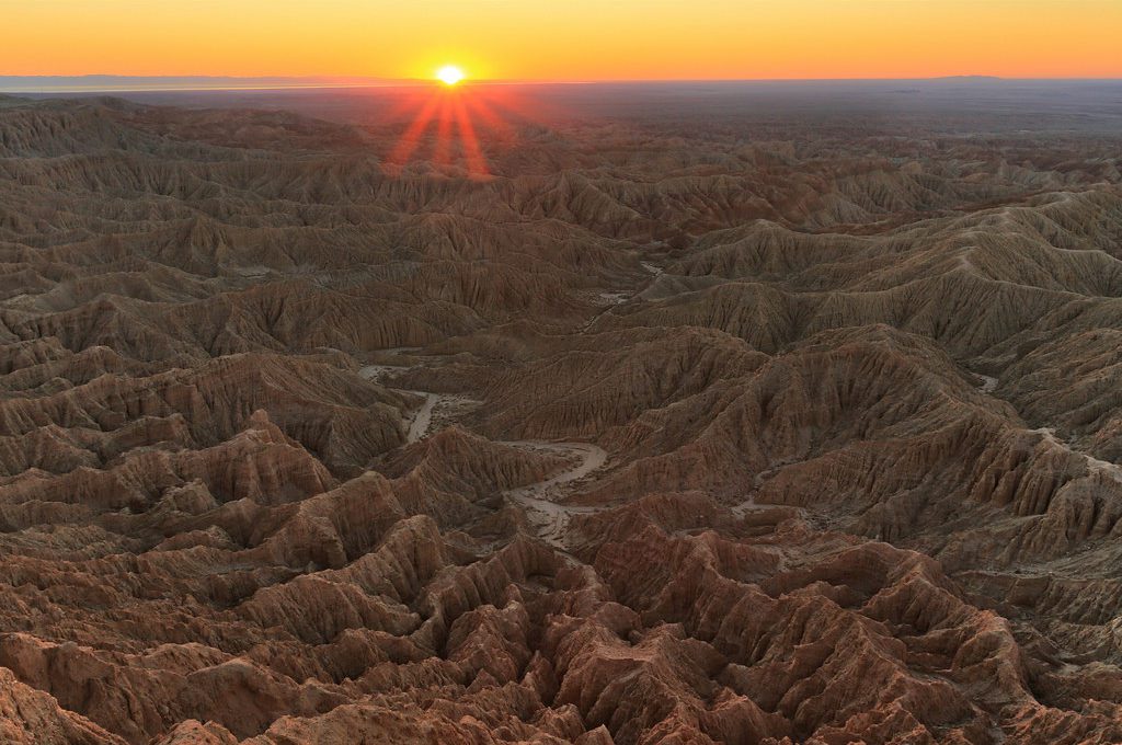
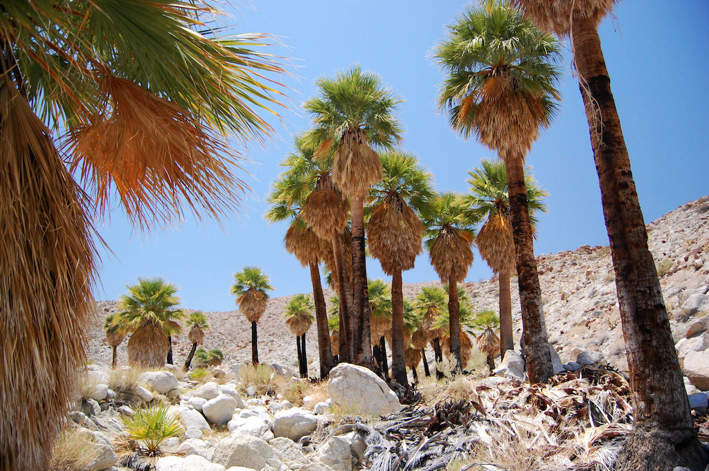
23. Anza-Borrego Desert State Park (California)
Wrinkled badlands span a jagged horizon, a rocky creek runs through a cluster of palm trees in a hidden oasis, and in the spring — millions of orange and purple petals overlay entire desert meadows. Such are the dramatic landscapes of Anza-Borrego State Park, the second largest state park in the continental United States.
An often overlooked state park in the Colorado Desert, it encompasses more than 600,000 acres and is home to one of California’s largest palm oasis and striking scenery.
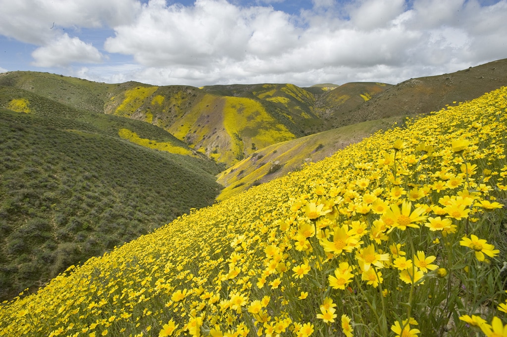
24. Carrizo Plains National Monument (California)
Located in an extremely remote area in California about 100 miles north of Los Angeles, the Carrizo Plain National Monument is a 246,812 acre area that makes up the largest single native grassland in California.
It’s home to a vast salt lake, a famous petroglyphs site, and most famous of all, brilliant wildflowers that burst into life and carpet the hillsides in resplendent colors of purple, yellow, and green.
This illustrious concentration of so many flowers on the slopes of Carizzo Plains led the famous outdoorsman, John Muir, to remark about this place that “one foot step would press about a hundred flowers.”
25. Heart Rock Trail (California)
Water babbles from a creek that runs along a dirt trail flush with Jeffrey pines, black oaks, and a rich panoply of mountain forest flora. At the end of this charming trail, a waterfall pours over a small rocky canyon where an almost perfectly symmetrical heart-shaped rock forms a small pool.
Found in the Valley of Enchantment in Southern California, the Heart Rock Trail is only about one mile round trip and involves very little elevation gain, making it a great choice for families, beginner hikers, and of course couples looking for a less strenuous alternative for exploring California’s beautiful San Bernardino Mountains.
26. Fossil Falls (California)
The name Fossil Falls is a little misleading because you won’t find any “falls” and the place isn’t exactly a hotbed for fossils. However, rest assured, the volcanic landscape here doesn’t disappoint. Polished clumps of charcoal-colored basalt form a canyon which from afar, appears to be nothing more than a messy pile of rocks.
Yet, suddenly, as you move closer through the piles of vast geological history, a sculpted work of art emerges. Patches of brush dot the top of the canyon and as you peer into the gorge, you find murky green ponds settled into deep pits along its mysterious canyon floor.
It’s a rare setting that’s made even more photogenic by the backdrop of snow-capped mountains and a deep red cinder cone, known locally as “Red Hill,” that towers formidably nearby.
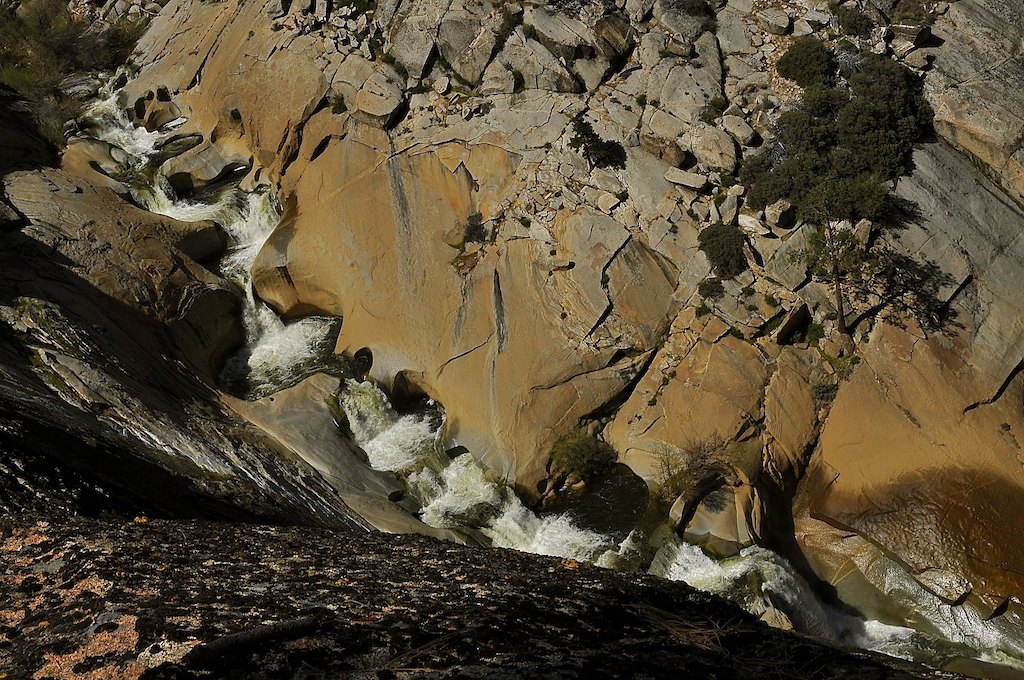
27. The Seven Teacups at Sequoia National Forest (California)
Snowmelt waters originating from high in the Sierras tumble down a staircase of seven circular pools carved into a steep granite canyon in Sequoia National Forest. Known as the Seven Teacups and frequented by canyoneering and kayaking adventurers alike, these treacherous waterfalls spill at heights ranging from 6 to 40 feet.
Their strong currents not to be taken lightly, the Teacups can be an exhilarating adventure for adrenaline junkies or simply a destination where hikers and photographers can delight in a great outdoor experience.
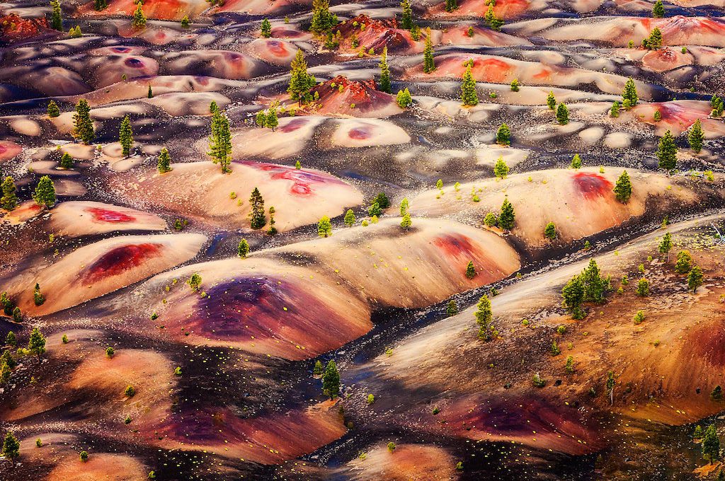
28. Lassen Volcanic National Park (California)
Rolling mounds, dotted with pine trees and smeared with blotches of red and charred yellow lay out before you from atop the summit of the Cinder Cone. These “Painted Dunes” are the result of volcanic activity occurring 300 to 400 years ago — a very short period of time on the geological scale — and are only one of several phenomenal highlights at Lassen Volcanic National Park.
Hidden in the interior of Northern California at the southern end of the Cascade Range, Lassen is one of the only places in the world where you can find all four different types of volcanoes, not to mention a hydrothermal area basin with turquoise steam pools and bubbling mudpots.
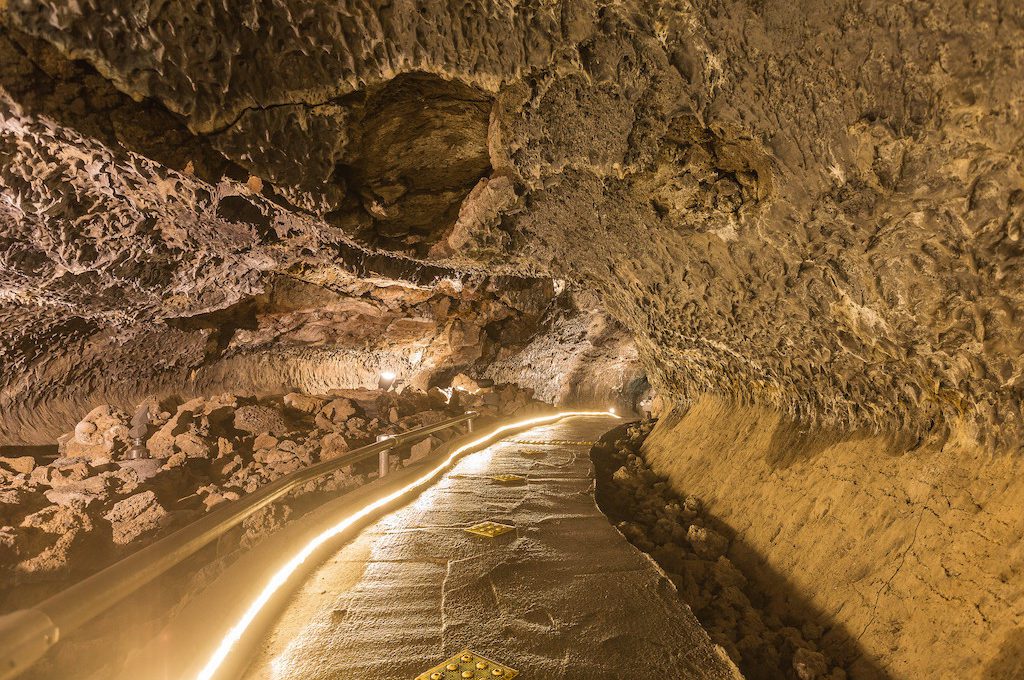
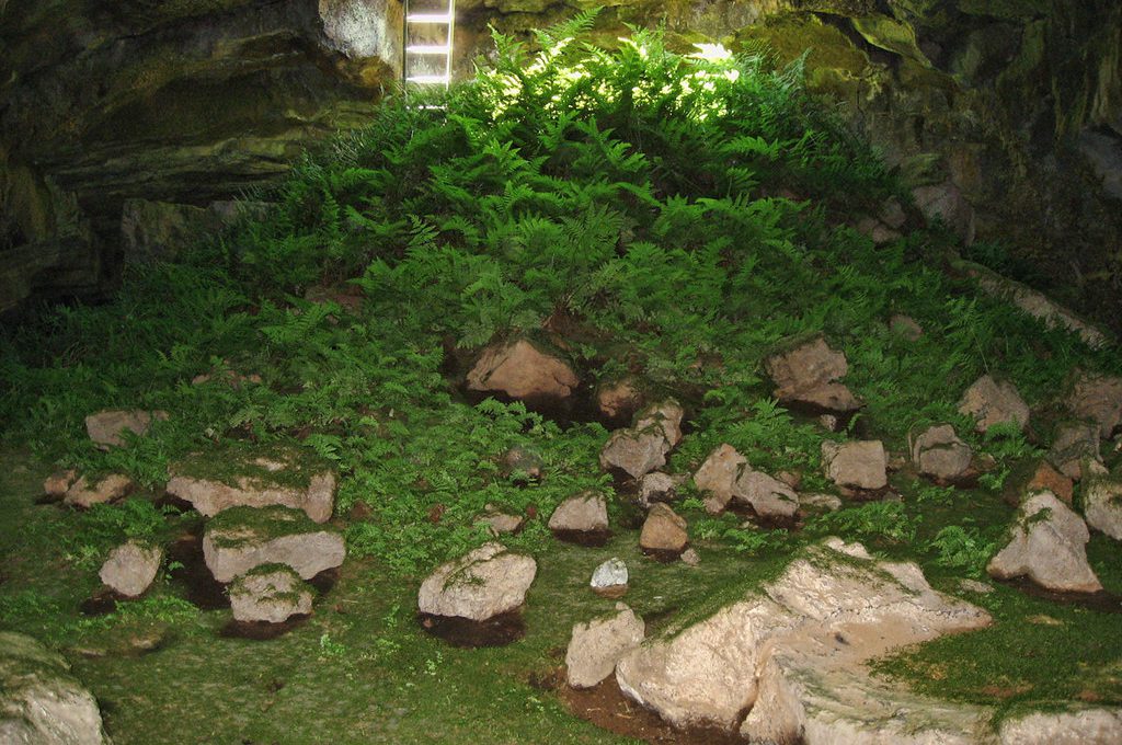
29. Lava Beds National Monument (Modoc County, California)
Home to a host of battlefields from the Modoc War, Lava Beds National Monument is a hidden gem tucked away in Northern California that brings to life the region’s often overlooked volcanic history and displays some of the best-preserved petroglyphs and pictographs in the country.
Some of the brilliant sights here include lava tubes lit with red, magma-inspired lighting, an amazing sprout of bright green ferns in the Fern Cave, and the alien-like ice stacks found in the Crystal Ice Cave.
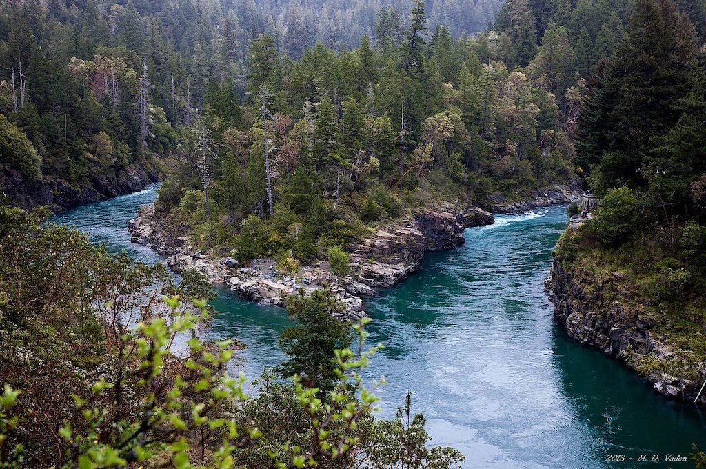
30. Jedediah Smith State Park (Crescent City, California)
Despite loggers destroying up to 96% of old-growth redwoods, there are still plenty of places to witness these spectacular trees located throughout Northern California.
One such place is Jedediah Smith State Park, home to Stout Grove where in the late afternoon golden sun rays fan-out through a shadowy canopy of some of the oldest coastal redwoods in the country, offering you the kind of intimate encounter with nature that remains forever fresh in your memory.
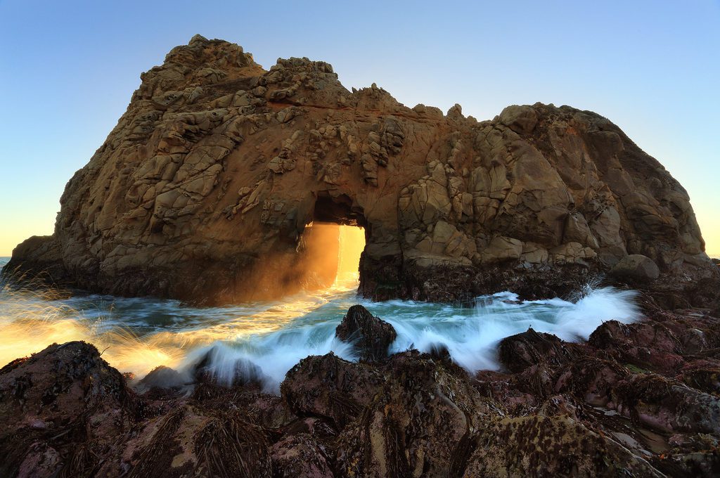
31. Pfeiffer Beach at Los Padres National Forest (California)
One normally looks up to the sky and the clouds at sunset for those unique shades of purple best captured at the coastline, but here at Pfeiffer Beach, you’ll find those same swirls and patches of pastel purples and blues shining back at you not from the sky above, but from the sands below as the cold waters of the Pacific wash over them. And if you visit near the time of the winter solstice, you’ll be awe-struck as sunsets literally burst through the golden doorway of Keyhole Rock.
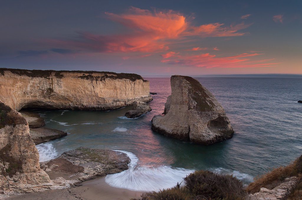
32. Shark Fin Cove (California)
Shark fins rising from the ocean don’t typically entice visitors to come visit the coast, but this place is the exception.
Here, a menacing dorsal-shaped sea stack provides the dramatic centerpiece for a scenic cove surrounded by deep inlets and alcoves. From atop the white bluffs, or through the shadowy windows of one of the sea caves below, you can admire this stunning byproduct of erosion that’s earned this beach its name, “Shark Fin Cove.”
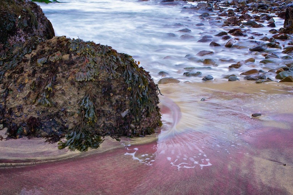
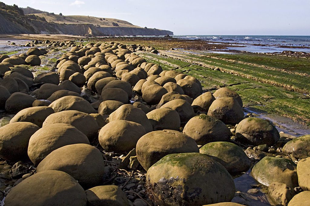
33. Bowling Ball Beach (California)
At low tide, hundreds of “bowling balls,” ranging from three to six feet in diameter, line up in rows along the shore.
From dinosaur eggs to visitors from another world, there has been much speculation over the years as to the source of these incredible formations; however, these massive spherical rocks are made up of sandstone and were formed when mineralized water seeped into the layers of sandstone sediments causing these masses to harden.
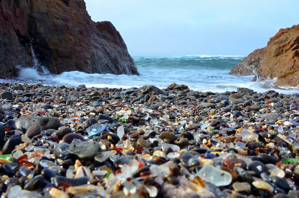
34. Glass Beach (California)
Thousands of tiny polished glass pieces glisten along the shoreline at Glass Beach, near Fort Bragg, CA. Like rubies and emeralds, these treasures shine brightly among the beds of black and grey pebbles in which they lie.
It’s a sight to behold – and one that’s been in the making for decades, albeit not always intentionally as these shiny glass pieces are the products of waste dumping on the coast that went on from the early 1900s to the late 1960s.
35. Cove Palisades State Park (Oregon)
Designated as a National Natural Landmark in 2011, the 200-acre peninsular plateau known as the “Island” is surrounded by dramatic cliffs that run 200 to 700 feet above of the pristine blue waters of Lake Billy Chinook.
These high cliffs have served as deterrent to livestock that would normally graze and devour most of the vegetation in the area and as a result rare vegetation unique to the area has survived over the years leaving the Island at Cove Palisades as one of the last undisturbed areas in the entire United States for rare native plants including western juniper wheatgrass and bitterbrush.
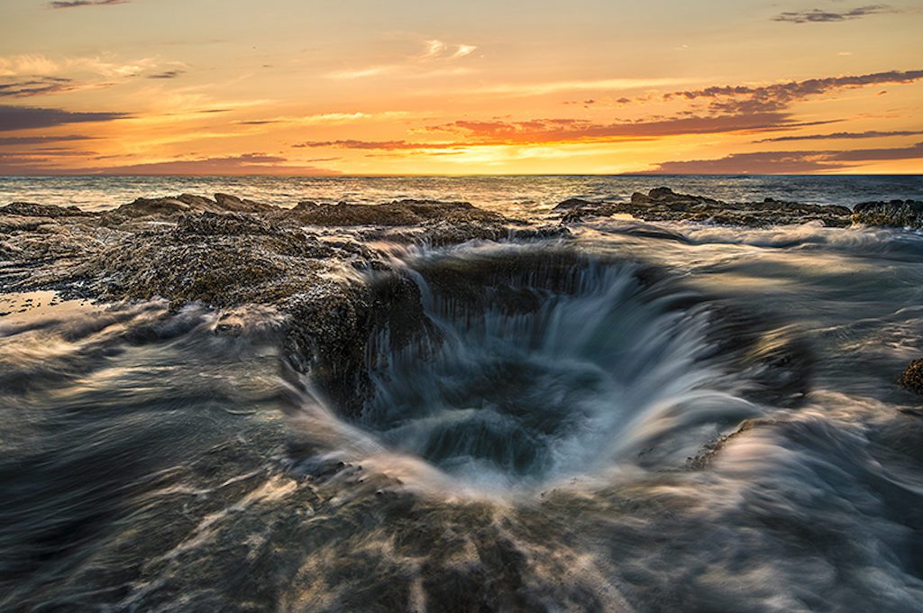
36. Thor’s Well at Siuslaw National Forest (Oregon)
Thor’s Well, sometimes referred to as the “Pacific Gateway to the Underworld,” is one of the most exhilarating sites along the West Coast of the United States.
During high tide or when the surf is raging from incoming Pacific storms, waves wash into a large hole, estimated to be around 20 feet deep, creating one of nature’s most intriguing sites: a natural fountain that spews salt water several meters into the air and then sucks the water back down into its depths creating a spectacular, and sometimes eerie, natural wonder.
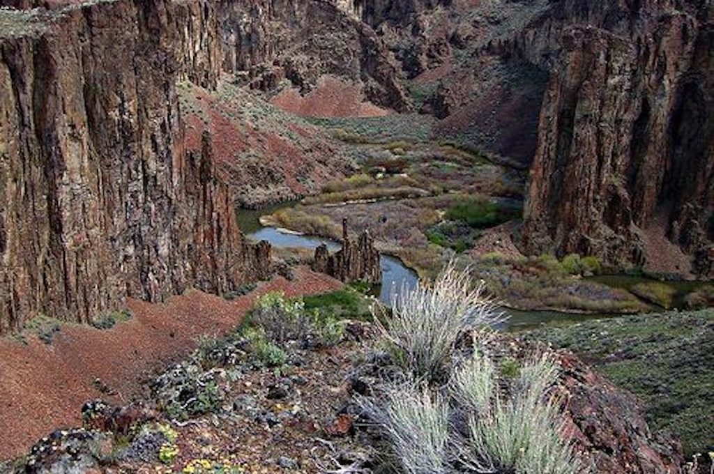
37. Leslie Gulch & the Owyhee Canyonlands (Oregon)
Situated in eastern Oregon and southwestern Idaho are the Owyhee Canyonlands, one of the largest roadless areas in the entire United States covering 5 million acres.
The entire area is full of canyons, deep gorges, more than 200 species of animals, rare flora, and meandering rivers that span for hundreds of miles.
There are several different areas to explore within the Owyhee Canyononlands but one of the most striking and accessible is Leslie Gulch, full of spires made up of “tuff” rocks and rhyolite ash products from various volcanic eruptions that have taken place in the region dating back as far as 15 million years to as early as 100,000 years ago.
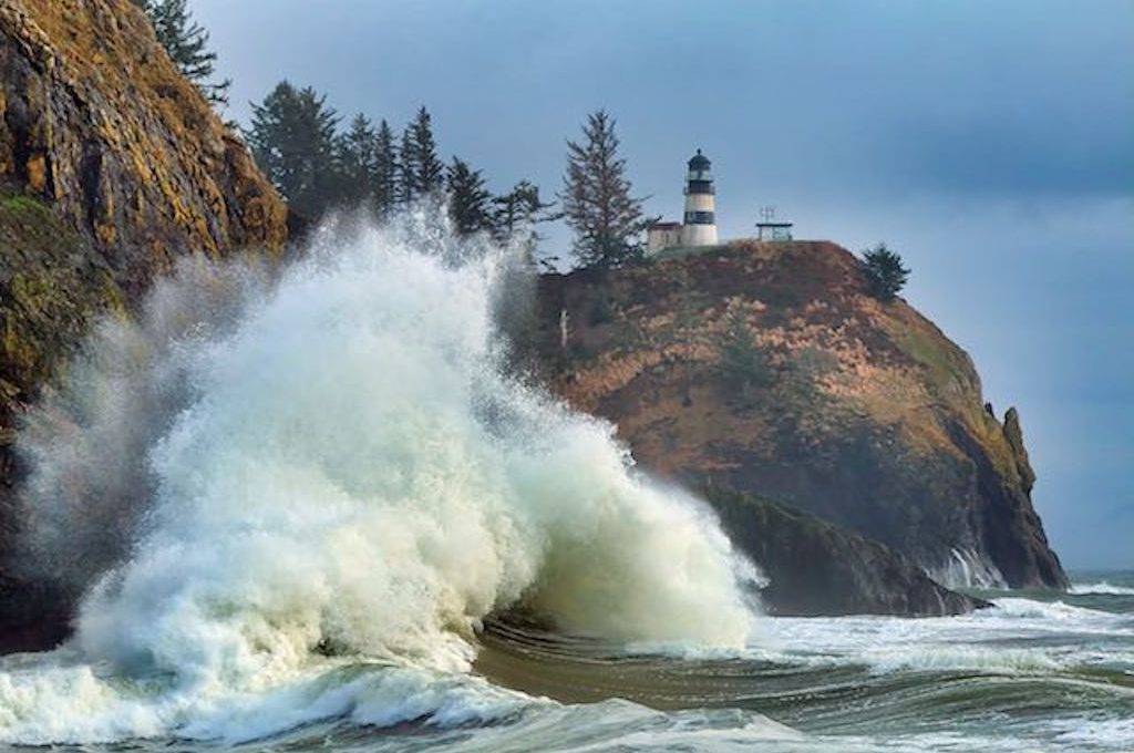
38. Cape Disappointment State Park (Washington)
Cape Disappointment, where Lewis and Clark finally reached the Pacific after completing one of the most legendary expeditions in American pioneer history, is located at the treacherous mouth of the Columbia River.
Today, it’s known as the “Graveyard of the Pacific,” a name earned after almost 2,000 large ships sunk in and around this area ever since the early settlement years . One such ship known as the Vandalia, foundered nearby in 1853 and bodies allegedly washed up on the shores of an inlet now known as Dead Man’s Cove.
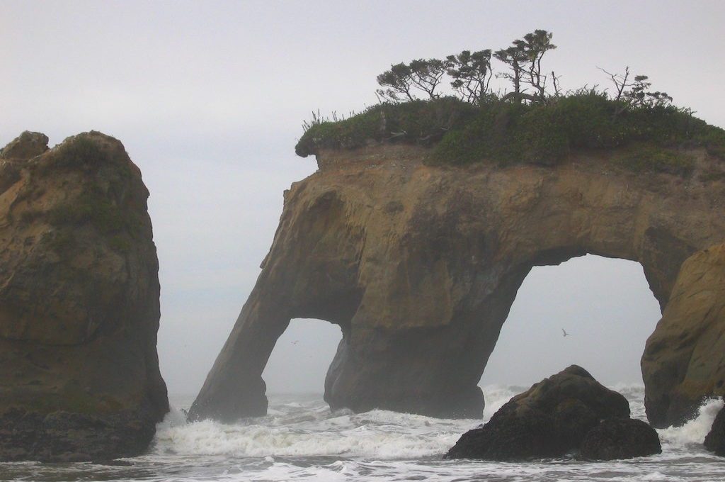
39. Elephant Rock (Washington)
On the often fog-shrouded shores of the Quinault Indian Reservation in Washington, lies Elephant Rock, an impressive natural double sea arch with an uncanny resemblance to an elephant, complete with eyes, large ears, and of course, a trunk. You’ll need to be accompanied with a member of the Quinault to gain access to this beach but the extra legwork will be more than worth it.
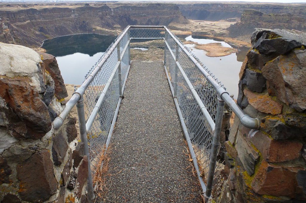
40. Dry Falls State Park (Washington)
The skeletal remains of what was once the world’s largest waterfall – four times the width of Niagara Falls – span across an area known as the scablands in eastern Washington.
Floodwaters that would’ve toppled 30-story buildings scoured these lands and rushed over the cliffs as fast as automobiles speeding down an interstate, creating the spectacular falls that’s estimated to have been over three miles wide.
Today, all that’s left of this extinct natural wonder are barren canyon walls whose dry, volcanic rocks crumble down the same cliffs where the most powerful and magnificent waterfall of all time once poured.
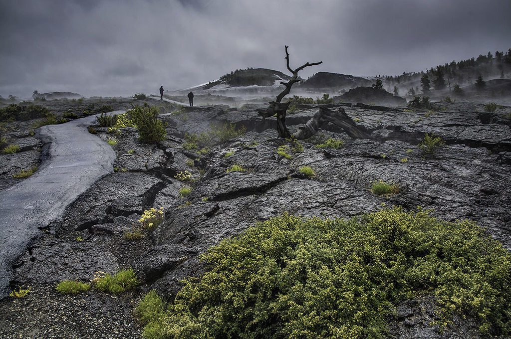
41. Craters of the Moon National Monument (Idaho)
Once visited by Apollo Astronauts for training purposes, Craters of the Moon National Monument is a large area in central Idaho encompassing over 1,100 square miles of lava fields and grasslands.
The park is known for its toothed landscape consisting of three lava fields which in addition to being rich in early American pioneer history, display some of the most intriguing volcanic rock formations in the country, including “mini-volcanoes” and the deepest rift cave in the world. It’s also a place where you can find fascinating vegetation like limber pine trees, whose branches are so flexible they can be tied into knots.
42. Bruneau Canyon Overlook (Idaho)
At the Bruneau Overlook, thick rugged tiers of cemented volcanic ash rise over 800 feet from the canyon floor where the rock-strewn Bruneau River meanders through the bedrock.
The view captures the Bruneau-Jarbidge Wilderness, one of the most scenic segments of the desolate Owyhee Canyonlands Wilderness and is one of the best photograph opportunities in Idaho.
43. City of Rocks National Reserve (Idaho)
Spanning over 14,000 acres with some of the oldest rocks in North America, the City of Rocks is rich in pioneer history and geological wonder, where old wagon wheels and ruts can be found among eroded spires and monoliths that tower more than 60 stories high.
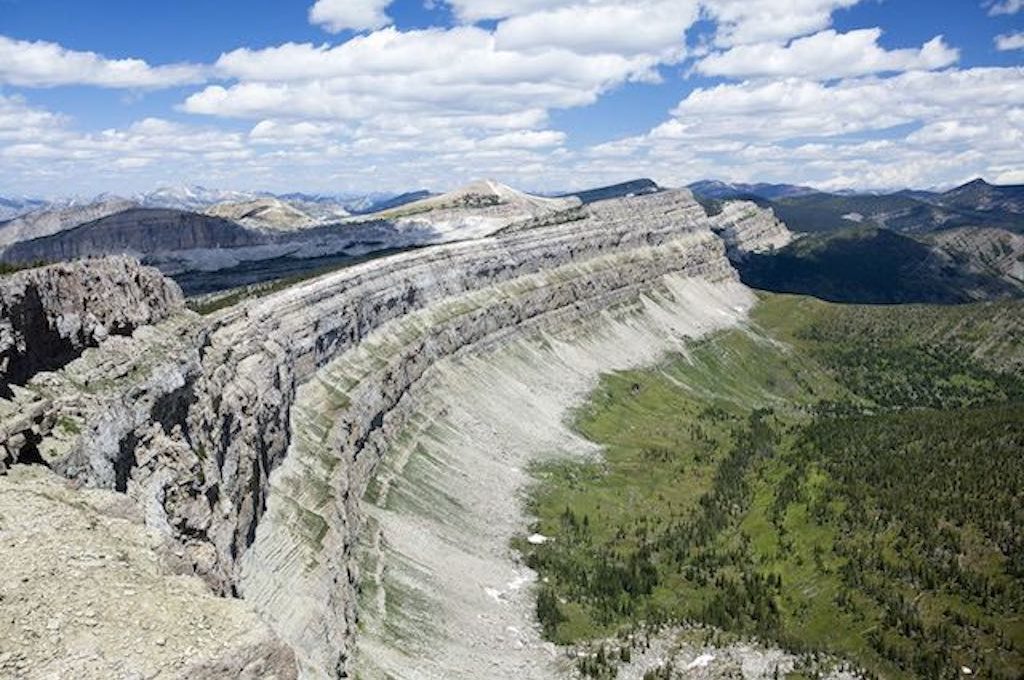
44. The Chinese Wall at The Bob Marshall Wilderness (Montana)
Imposing, yet inspiring, the Chinese Wall soars as high as a 100-story building and stretches for nearly 20 miles along the Continental Divide in the Bob Marshall Wilderness in Montana.
It might seem hard to believe that such a massive formation like the Chinese Wall could remain so unknown for so long, but when you consider that accessing this natural wonder requires over 60 miles of hiking through a true, deep wilderness where crossing paths with grizzly bears and wolves is a real possibility, you quickly understand that the intrepid souls who lay eyes on this marvel are few and far between.
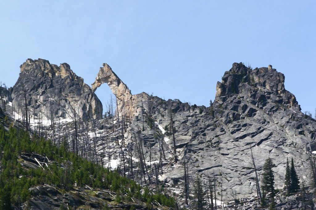
45. Blodgett Arch at Bitterroot National Forest (Montana)
Found at the western edge of Montana, Blodgett Arch is one of those natural wonders that would be on top of everyone’s “to see” list if it were only more accessible. Towering high above the tree line, this giant granite arch stands among jagged, dark grey peaks in the heart of the Bitterroot National Forest.
It’s believed that Ice Age glaciers which formed on either side of the mountain ridge created cracks in the rocks and that the glacial ice applied just the right kind of pressure to push out the center of the arch and create this amazing site.
46. Makoshika State Park (Glendive, Montana)
The landscape at Makoshika State Park, Montana’s largest state park, is a prehistoric wonderland of otherworldly rock formations. Shiny bronze caprock crumbles down the fissured sides of grey badlands onto cracked soils, exposed cliff sides reveal excavated dinosaur vertebrae, and benches offer tired hikers resting points at overlooks where panoramic views stretch for miles.
But one of the best things about Makoshika is what’s not there. When you visit this outdoor wonderland, you’re likely to beat the crowds and have many of the rocky trails to yourself at this lesser-known state park that protects approximately 20% of contiguous Montanan topography.
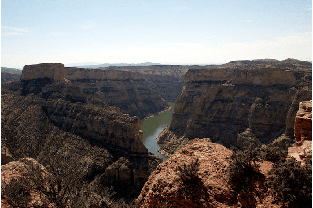
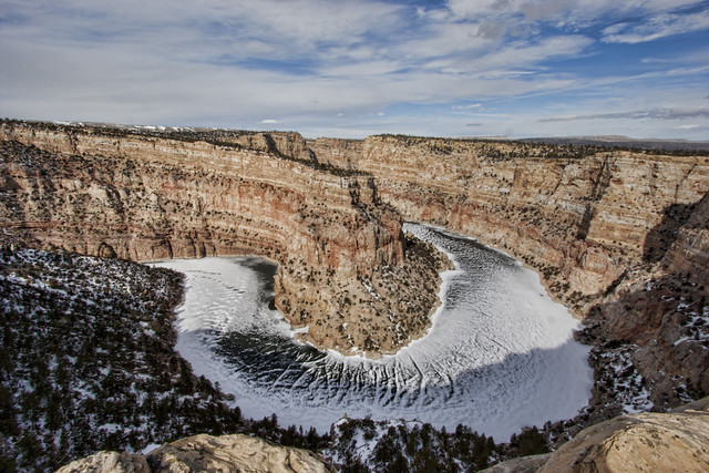
47. Bighorn Canyon National Recreation Area (Wyoming/Montana)
Emerging out of the canyon walls like a battleship and rising over 500 feet, the towering cliffs at Devil’s Canyon Overlook may be the most stunning canyon scenery in all of the Northern Rockies.
Nonetheless, it’s just one of the many extraordinary sights found at Bighorn Canyon National Recreation Area, located on the border between Wyoming and Montana. It’s an area so full of geological wonder and harsh terrain that if able to talk, it would tell endless stories of the struggle that Native Americans and early pioneers endured as they navigated their way through these treacherous desert canyons.
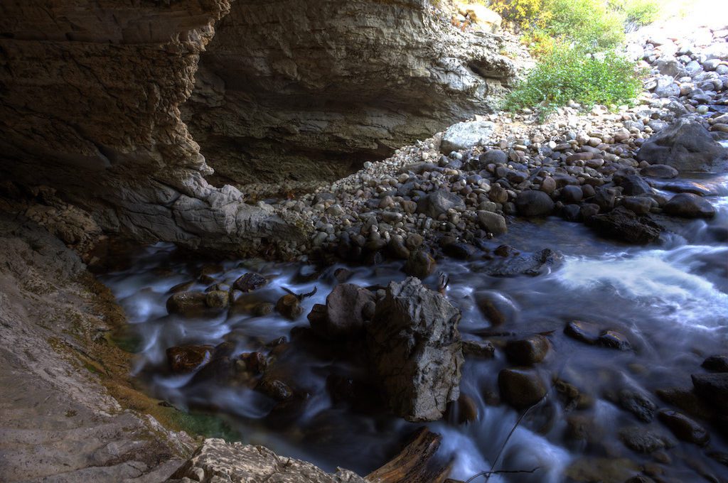
48. Sinks Canyon State Park (Fremont County, Wyoming)
Water gushes over a rocky riverbed, bubbling and gurgling as it drops into the shadowy depths under the ridges of a limestone canyon and disappears into the abyss.
This mysterious cavern is known as “the Sinks” and it’s where the Popo Agie River enters before flowing through an underground labyrinth where it undergoes several mysterious changes before reemerging about a quarter of a mile downstream and spilling into a deep green pool known as “the Rise.” Ranked as one of the best state parks in the country by National Geographic, Sinks Canyon State Park is a true natural wonder chock-full of fascinating geology and history.
49. Fremont Canyon (Alcova, Wyoming)
In the midst of winter, apricot-colored cliffs dotted with vegetation, tower over a tight bend on the snow-coated, frozen waters of North Platte River. It’s one of just several extraordinary viewpoints along Fremont Canyon, near Casper, Wyoming.
The area is most well-known for its rock climbing and boating opportunities, but it’s also a great place just to explore and capture some stunning canyon scenery, while taking time to ponder some of the area’s rich frontier history.
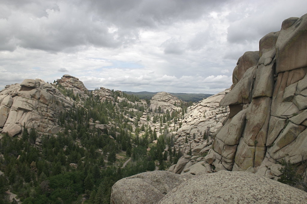
50. Vedauwoo (Buford, Wyoming)
Vedauwoo, known to the Arapaho Indians as “Land of the Earthborn Spirit,” is an enchanting recreation area full of billion-year-old granite outcroppings, many of which appear to be defying gravity with their peculiar poses.
Interestingly, the magma composition of these boulders is identical to the magma underlying Yellowstone National Park, meaning that the boulders at Vedauwoo represent what the Yellowstone of the future will look like once its magma crystallizes and the overlying rocks are eroded away.
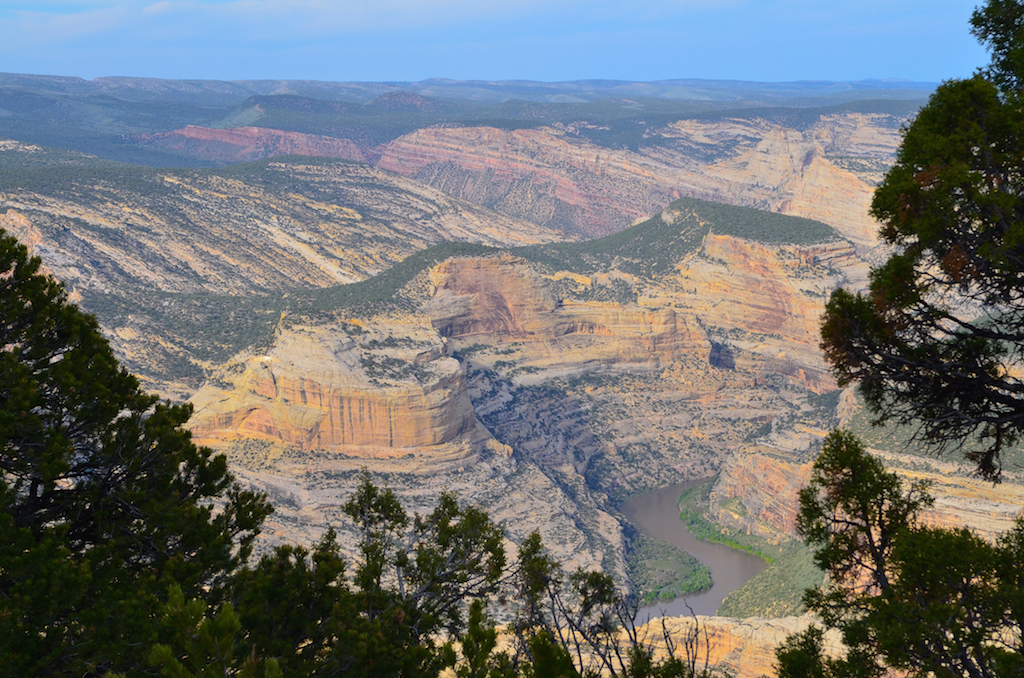
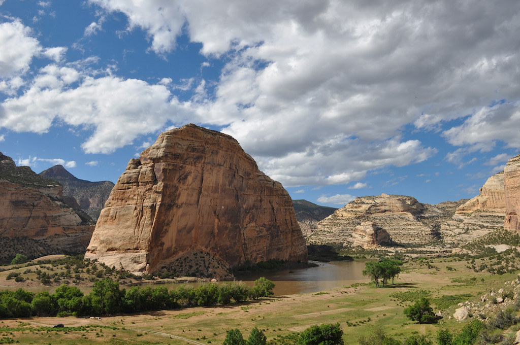
51. Dinosaur National Monument (Moffat County, Colorado)
Dinosaur National Monument is not only one of the best places in the world to view dinosaur fossils, it’s also home to some of the most striking canyon landscapes in the entire United States. Scenic roads, both paved and unpaved, wind through the rugged interior of the monument taking visitors past unique rock art, early 20th century ranches, and several stunning viewpoints – some of which look down over 2,000 feet to the Yampa and Green Rivers as they meander through these lush, green-topped canyons. Remote, desolate, and packed with ancient geological history, this National Monument beckons exploration.
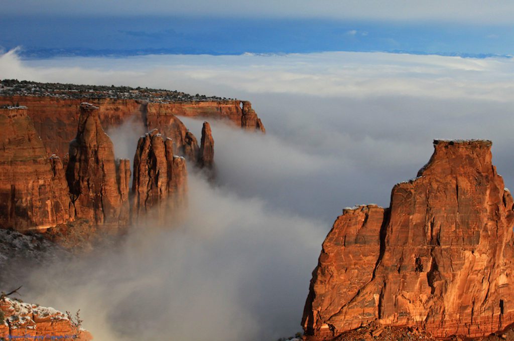
52. Colorado National Monument (Fruita, Colorado)
In the morning, fog shrouds the banks of towering sandstone cliffs as tall, jagged spires slice through the ephemeral mist and soar like rocky islands floating among the clouds.
If the dramatic sandstone cliffs form the heart of this monument, its spirit lies in the determination and willpower born from one man, the great Colorado trail builder and park ranger, John Otto who devoted his life to preserving and promoting these exquisite canyon landscapes in Colorado.
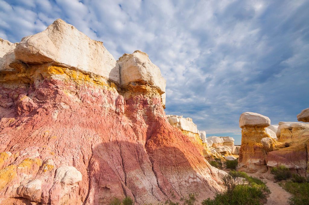
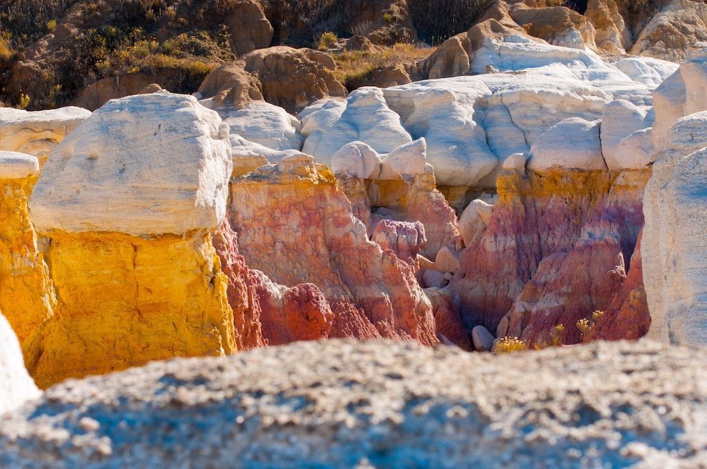
53. Paint Mines Interpretive Park (Calhan, Colorado)
Purple, pink, yellow, and orange pastels coat brittle walls of clay inside a fantastical labyrinth of white-capped hoodoos. A small weasel tiptoes out of a dark crevice and into plain sight, sizing you up before scampering back into its lair without a sound.
Remote, yet full of vivid colors and bashful wildlife, this kaleidoscopic collection of chasms, rifts, and slots – known as the Paint Mines – is unlike any other badlands in the country. Tucked away in a 750-acre park about 30 miles east of Colorado Springs, this fairly new interpretive park is one of the best-kept secrets of Colorado.
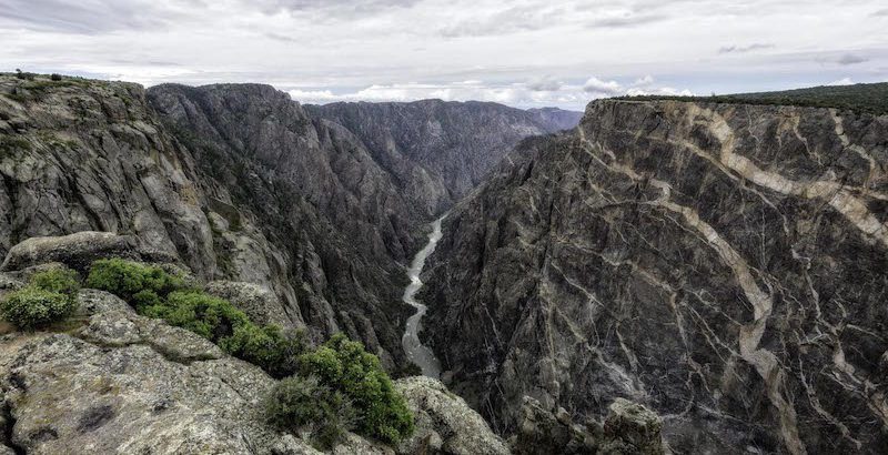
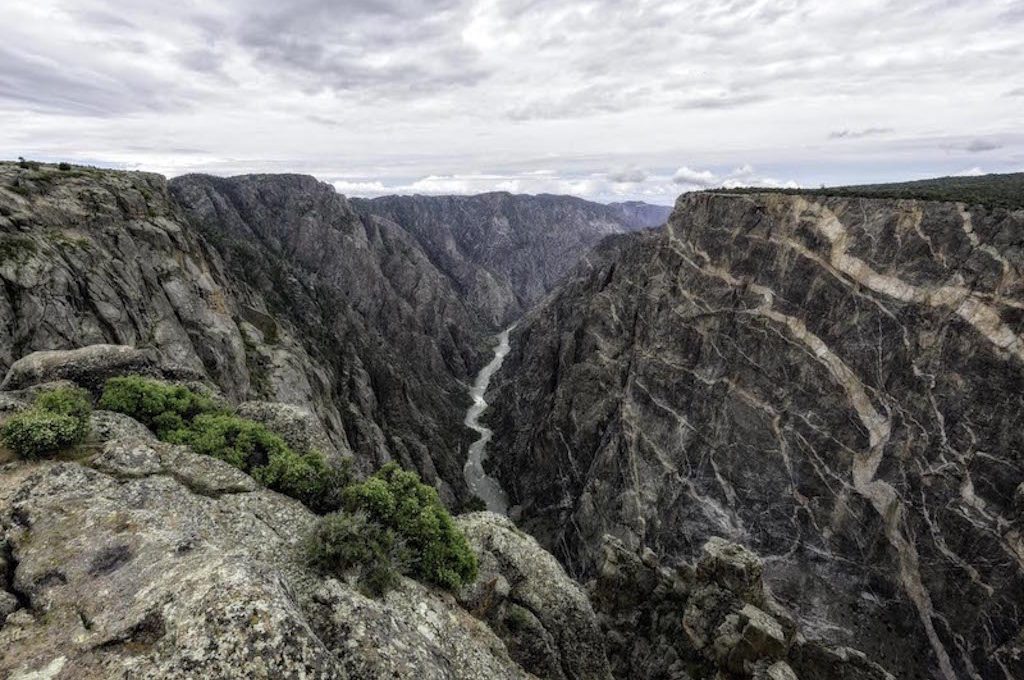
54. Black Canyon of the Gunnison National Park (Montrose, Colorado)
The name sounds like something out of a fantasy novel, “The Black Canyon of the Gunnison.” One of the steepest mountain descents in the world, Black Canyon earned its name from the limited sunlight that’s able to shine through these narrow canyon walls, which at their narrowest point are separated by a mere 40 feet.
Two spectacular scenic drives run along both rims of the canyon, and a number of overlooks and hikes offer one-of-a-kind scenic experiences to peer over immense drop-offs at the Black Canyon of the Gunnison National Park, located in western Colorado.
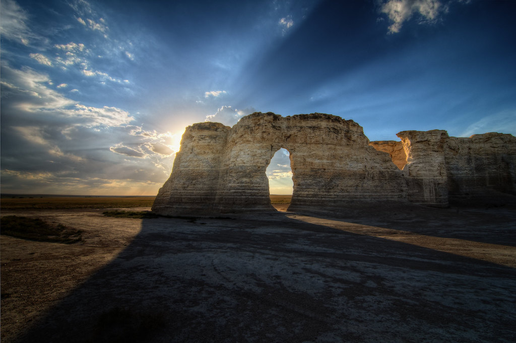
55. Monument Rocks National Natural Landmark
Constantly named as one of the natural wonders of Kansas, Monument Rocks is a destination that often surprises people when they come to find out that it’s located in the mostly flat state of Kansas. Monument Rocks, also known as the “Chalk Pyramids,” is an area where white chalk formations, some of which rise up to 70 feet high and take the form of awe-inspiring arches, stand clustered amid a flat, barren landscape.
It’s rumored if that after rains, these towering monoliths gives off a salty, oceanic scent, a testament to their ancient beginnings under the sea dating back to the Cretaceous Period.
56. Toadstool Geologic Park (Chadron, Nebraska)
In remote northwestern Nebraska, a strange moon-like landscape can be found at a place not known to many people: Toadstool Geologic Park. Also referred to as “The Desert of Pine Ridge,” it’s a fossil hotbed that’s home to bright badlands, cliffs, and an odd array of toadstools, many of which resemble strange objects like chess pieces.
Like what you see here and want to find more amazing places?

Check out my new eBook Hidden Gems of the Western United States to discover over 130 amazing places and gain fascinating insight into the geology, cultures, and environments of these places in addition to finding out all the essential information such as hours, admission prices, and pet policies, not to mention many specific tips that have been gleamed from hundreds of hours of research and personal experiences.
Best of all, 25% of net profits from the sales of this eBook will be donated to help kids in America gain access to our National Parks!
To buy this book on Amazon click here!
Cover Photo: Jordan Marsh, jmarshphoto.com
Daniel Gillaspia is the Founder of UponArriving.com and the credit card app, WalletFlo. He is a former attorney turned travel expert covering destinations along with TSA, airline, and hotel policies. Since 2014, his content has been featured in publications such as National Geographic, Smithsonian Magazine, and CNBC. Read my bio.